+9779849060643

Everest Basecamp Chola Pass Gokyo Trek (Deluxe Service)

17 Days

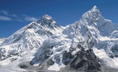
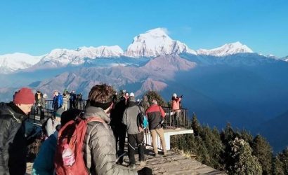
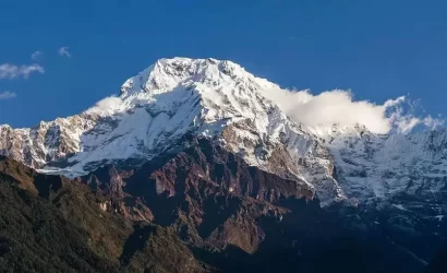
Everest Gokyo Cho La Pass Trek is an outstanding trek offering the spectacular views of the Himalayas. While Trekking in Nepal this particular circuit leads the trekkers to the source of the splendid Dudh Koshi River, magnificent Gokyo Valley, the great Ngozumpa Glacier, the famous Cho La Pass, and the popular view of the Gokyo Ri and Kala Patthar along with the Everest Base Camp and entirely through to the popular landmarks of the Everest region. The entire area is blessed with abundance of natural beauty, the soaring mountain ranges, colorful monasteries, friendly Sherpas and 360 degree panoramic view of the sky scraped mountain ranges including four above 8000 thousand meter massifs which includes Cho-oyu, Everest, Lhotse and Makalu.

Overview

If any trekking route in Nepal pushes the envelope in terms of adventure and difficulty, it’s the Everest Base Camp Cho La Pass Gokyo Trek. It forces the hikers to discover numerous secret locations, take in the breathtaking scenery, and get the ideal picture of Mount Everest.

Although the trek is a little more challenging than others, the Nepal Eco Adventure will take you on an interesting adventure. From Lukla onwards, your journey will be made easier and more enjoyable by the presence of a porter and trekking guide.

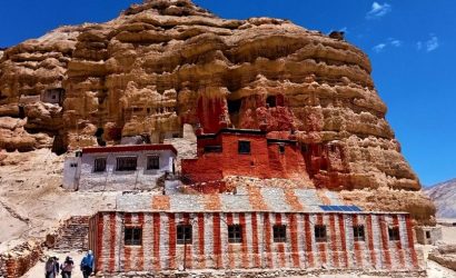
Due to caste migration over the years, you can even come across Brahmin, Chhetri, Sherpa, and Rai people. The majority of trekkers make a halt at Tengboche monastery, one of the most important tourist destinations in Khumbu.

At a height of 5,364 metres, Everest Base Camp is located to the south of Mount Everest. From Kathmandu, it is roughly 144 kilometres away, and the trek actually begins in Lukla. There are other towns along the trail that leads from this small Sherpa town, such as Namche Bazaar and Dingboche.

Itinerary

Arrival in Kathmandu and pickup from airport and drop in 3 start hotel in Kathmandu on BB plan.

Today you will be preparation for your trek. Our team will help you to get around town and look for your trek gears if required including trek maps. Rest you will have the whole day for yourself. You can go around Thamel area and enjoy local cuisine and meet local people.

We will depart from Kathmandu early in the morning and travel by plane to Lukla, which will take between thirty and forty-five minutes. Till then, take in the amazing views of rolling hills, wide meadows, nearby farms, and cliff faces.

We'll fly over the tall hills and traditional Nepali villages to reach the charming town of Lukla. We start our walk to Phakding with a short descent from the right bank of the Dudh Koshi River after a quick stop for brunch.

To reach Ghat, we make our way slowly through the pine forest and beyond the ancient Mani walls. There's a well-trod path that leads to Phakding, with plenty of ups and downs. When we get to the settlement, we'll go to a lodge.

Beginning with a minor stream crossing, the Namche Bazaar trek continues up the terraced hillside to Benkar. We follow the valley of the Dudh Koshi River below and onward into pine and rhododendron trees. We proceed past the Manjo village and into Sagarmatha National Park, where we pay the admission fee.

We will cross the Dudh Koshi River via the suspension bridge multiple times during the walk. The climb becomes exceedingly challenging with a steep and continuously ascending trail a few miles above Jorsale.

We may take in the breathtaking views of the surrounding lush hills, steep-sided peaks, and rocky landscape as we arrive in the town. Spend the night in a stunning resort near Namche.

We'll stay a day in the town because the walk from Namche is difficult and has an upward inclination. We'll walk to the twin villages of Kunde and Khumjung for acclimatisation, then we'll take the Everest View Hotel to return to Namche. These villages are less crowded than other communities.

Today's day walk could take four to five hours of enjoyable walking. We will be treated to an amazing vista of numerous snow-capped mountains, including Ama Dablam, Mount Everest, Thamserku, and others, after we arrive at the village. Trekkers also frequently stop in these settlements for lunch and lodging at night.

We'll walk up the craggy slope for an hour until we reach the Everest View Hotel from there. The challenge is finally rewarded with a breathtaking view of Thamserku, Ama Dablam, and Mount Everest from the hilltop.

Beautiful views of majestic villages, verdant forests, and steeply inclined valleys will be presented to us. We'll go down the trail to return to Namche village after taking in the views. It's also fun to explore Namche Bazaar and its vibrant local businesses. We'll stay at the lodge for the night.

We had breakfast and then headed towards Tengboche. As we approach the steep hill, we will leave the ground and enter the forest, where the walk becomes a little easier. We'll descend the trail to the roaring river at Phungi Tenga shortly after that.

After traversing the river over an antiquated wooden bridge, we commence our ascent. We'll have a great lunch at a tea restaurant before starting the day's last ascent. From this point on, the walk becomes very strenuous due to the low oxygen levels in the atmosphere.

After a protracted and hard ascent, we will ultimately reach Tengboche, a small settlement in the Khumbu subregion, to conclude our journey. With the breathtaking backdrop of Ama Dablam, it is home to one of the oldest Tibetan monasteries in the nation. Tengboche, which is situated on a hill across Imja Khola, is a popular hiking destination for lodging.

We will visit Tengboche monastery early in the morning, participate in their prayers, and receive blessings. We'll depart the hamlet and ascend shortly after that, taking in the breathtaking vistas of Kantega and Ama Dablam.

Green slopes, Chortens, and many Mani walls appear as we keep navigating the path. While the lower track goes to Pangboche Olin, the upper trail passes Pangboche.

A day off is much needed after such a long and exhausting journey. We will thus rest at Dingboche the next day in order to regain our full vigour for the longer walk. We'll take a primarily upward hike to Chukhung Valley to make the most of the day.

The path ends at the glacial moraine after passing through the Imja Khola Valley and pastures with stone walls. The trails are rocky and uneven in this area, making it challenging for hikers to manoeuvre. But as soon as you get in the valley, Lhotse and Nuptse's breathtaking appeal will leave you speechless.

In addition to offering us amazing views of Mt. Ama Dablam, the walk rewards us with a view of Lho and Nup Glacier. We explore the valley for a short while before returning to the settlement to spend the night.

Rising above Chukhung village is Chukhung Ri, a much-loved side trip for acclimatisation. With its distinct geographical characteristics and landforms, the trail to the summit is as remarkable despite its steepness and roughness.

An alternate route that gets hikers ready for the Cho La Pass trip is Nagarjun Peak, which is 5,050 metres high. The pathways, which spiral up and down before coming to a clifftop, are also difficult. Hiking up to 5000 metres Nagarjun Peak offers fantastic views of Mt. Makalu, the fifth-highest summit in the world.

We now travel back to the route that leads towards Pheriche after having such a great day at Dingboche. We begin the day with a strenuous climb up the hill's edge, offering stunning views of Island Peak and Chukhung Valley.

We arrived in Dugla after travelling from Dingboche village for around two hours on foot and traversing a small brook via a wooden bridge. We take a brief break and have lunch at a little teahouse located in the village. We'll resume our uphill walk shortly after that, which could take an additional hour or so, depending on our speed.

This trek is a little strenuous, but it's well worth it because of the breathtaking views of Mt. Pumori, Kantega, and Cholatse. As we travel to the isolated community of Lobuche, we'll be able to take in the breathtaking views of soaring hills, craggy valleys, and sparkling snow-capped peaks. Except for a few resorts and camping places, Lobuche has fewer communities than Dingboche.

As we hike to Gorakshep and Everest Base Camp, this will be a demanding and exhausting day on the path. An early trek from Lobuche to Gorakshep will give us a good start to reach the base camp on time and take in the breathtaking surroundings because it's a long way to the campsite.

We take the steep moraine route out of the hamlet, which offers a stunning view of glacial lakes and icebergs. The difficulties are increased by the steep, rugged, and loose-rocked path that leads to Gorakshep. Trekkers must exercise extra caution when traversing the course because there is little oxygen at this height.

At 16,942 feet high, Gorakshep is a little village perched on the brink of a frozen lakebed. Once we had lunch and stopped by the village teahouse, we head northeast to Everest Base Camp.

The tough path with boulders and trash makes the three-hour hike to the base camp a little taxing. Altitude sickness is brought on by the thin air, which doesn't make the journey any easier. The trail eventually comes to an end at the foot of the Khumbu Icefall after crossing the vertical glacier. From the Everest Base Camp, we have an amazing view of Mt. Everest, Nuptse, and Cho Oyu.

You can also see rocky mountains, shimmering Khumbu glaciers, and a variety of scenery while exploring. After our tour is done, we take the same route back.

We go out on our difficult walk to Kalapatthar as soon as the sun rises. It takes two to three hours to complete the trail, which is entirely uphill. Along with some breathtaking views, the ascent to the peak offers the closest photo opportunity of Mount Everest. It feels as though you are very next to the mountain from the clifftop in the gentle wind.

The entire sky appears magnificent due to the captivating orange and crimson hues of the sunrise. We head down to Dzonglha after having a terrific experience in Kalapatthar and seeing the sunrise.

At the beginning of the walk, there are large rocks and stones throughout the rugged pathways. The hike gets a little easier after they descend from a steep top for a few miles. On the way to Dzoglha, there are a few teahouses where you can stop and enjoy some warm tea.

After that, the race loses some of the elevation it had gained and becomes somewhat level. The trail runs from the skirt of the hill and becomes narrow and steep after a quick descent. The final hours of the hike to Dzonglha are quite challenging because they are uphill all the way. Although there's an amazing view from here, we'll allow ample time to recuperate at the teahouse.

Wake up early in the morning and have breakfast as we depart for the trip to Cho La Pass in next to no time. The pass is on the Gokyo path and starts with a difficult ascent over rocks and mountain ridges before converting to an icy track. It will be difficult to reach the summit without crampons, gaiters, and ropes to climb the slick trail from this point on.

We will reach the peak pass after a few hours of walking uphill. There are no visible human settlements in the vicinity of Cho La Pass. The only things that around it are majestic glacial lakes, snow-capped hills, and towering mountains.

Numerous vibrant prayer flags can be seen at the top of the hill, waving in the breeze. We climb down the snow-covered trail to Thangnak after taking in the scenery. Our descent will require considerable caution due to the ice, loose rocks, and boulders that make up the landscape.

Remember to pack thick clothing because it's going to be chilly outside. Thangnak settlement is located 15,850 feet above sea level, west of Dzongla. Trekkers can spend the night at a few teahouses in the village.

Although the hike to Thangnak was intense, ascending Gokyo is significantly more taxing on the body. It's challenging to keep up the pace when the trail crosses a glacier. Stairs lead uphill through the Ngozumpa Glacier and along the slender valley.

The first Gokyo Lake will be encountered after another hour or two of navigating the rough terrain. Thonak and the other five glacier lakes, Gokyo Lake and the surrounding shimmering mountains and rock cliffs, provide an amazing vista.

We reach fifth Gokyo Lake after navigating the challenging terrain up ahead, which rewards us with a spectacular view of Mt. Cho Oyu and Gokyo Ri. The Gokyo Lakes, located between 4,700 and 5,000 metres above sea level, are the highest freshwater lakes in the world.

We'll return to the village after enjoying some amazing time by the lake. One of the world's highest communities, Gokyo Valley is located at a height of 4,750 metres. The community offers a wide selection of motels, guesthouses, and inns for lodging.

We spent the prior day exploring all five of the Gokyo Lakes, so today we're going to Gokyo Ri. Early in the morning, we will set out on the journey, beginning with a difficult ascent from the southern slope of Ngozumpa Glacier, south of Taujun Lake.

We'll walk carefully and slowly because these routes are rough and steep. When we reach the summit, we are rewarded with breathtaking views of Lhotse, Gyachung Kang, Makalu, Nuptse, Cho Oyu, and other mountains. At the summit of Gokyo Ri is a small village made up of a few stone dwellings.

Following the sighting, we retrace our route to the trailhead and descend to the Dole. The walk takes the same route as before, passing through the Ngozumpa Glacier after leaving the lake. Numerous Tibetan chortens may be seen along the route, including one that offers a breathtaking view of Thamserku and Kantega.

The views of Gokyo Valley gradually disappear after a mile of walking, but the towering hills and mountains are still visible. It takes 6-7 hours to walk from Gokyo Valley to Dole, depending on how the high altitude affects you.

Dole settlement is located in the Dudh Koshi River Valley to the north of Khumjung. It's simple because it's the primary rest area for Gokyo hikers.

From Dole, the trail descends gently till it reaches the level ground. We cross the suspension bridge after a leisurely stroll and go by various settlements, including Kyanjuma. We go towards the valley via the pine and rhododendron-filled alpine woodland.

There's a leisurely descent to Namche Bazaar and a breathtaking panorama of high mountains, verdant slopes, and verdant meadows. The lovely town of Namche will be reached after a brief stroll downhill past the Tibetan monasteries and Chortens.

This will be our final trek along the Everest region's trail. On this day, we'll descend the course from Namche to Lukla. This trip, in contrast to the previous one, is downward as you walk alongside the Dudh Koshi River and reach the suspension bridge. Before coming to a conclusion at Lukla, the trail travels through a pine forest and through a few towns.

This is almost the conclusion of our Everest Base Camp Cho La Pass Gokyo Trek, therefore it's time to return to Kathmandu. We'll walk a few miles to the Lukla airport after breakfast so we can board our aircraft. The thirty-minute drive from Lukla to Kathmandu offers breathtaking vistas of towering peaks and tumbling waterfalls.

We'll drive you back to the hotel after you land at the airport.

Includes

  • Free International and domestic airport pick up and drop off by private car/Jeep/ Hiace.
  • Accommodation on B/B plan in Kathmandu for 3-night in a 3-star hotel.
  • Meals on a full-board basis (Breakfast, Lunch, and Dinner/ the main course) during the trek.
  • Experienced, government-licensed, English-speaking trekking guides/Sherpas.
  • All guide salary, food, drinks, accommodation, transport, and insurance.
  • All necessary papers, including Everest National Park fee and trekking permit.
  • Tea House accommodation during the trek.
  • Airfare from Kathmandu – Lukla - Kathmandu, including airport departure tax in both Kathmandu and Lukla airport
  • Supplementary snacks: energy bars, crackers, cookies, etc.
  • Farewell Dinner at a Nepalese restaurant with traditional music and dance
  • An oximeter to measure your oxygen and Pulse level during the trek in the mountains is beneficial for all the trekkers to be aware of the high altitude sickness.
  • Compressive first aid box (Guide will carry it throughout the trek).
  • Emergency rescue operation assistance will be arranged in case of complex health conditions (funded by your Travel Insurance)
  • All government, Local taxes/VAT, and official Expenses

Excludes

  • Nepal entry visa fees (USD 30 for a day tourist visa can be obtained at the Airport of Kathmandu on arrival!)
  • Single supplement $200 extra.
  • Extra accommodation and meals behind schedule the schedules of this trekking trip program
  • All kinds of beverages, including alcoholic and nonalcoholic, as well as hot and cold drinks
  • Additional costs are out of management control due to the landscape, weather conditions, illness, changes in government policies, strikes, physical conditions, etc.
  • Surplus luggage charges for domestic airports (Max weight is 15-17 kg per person).
  • Personal expenses such as snacks, laundry, telephone, WIFI, hot shower, etc., at tea houses on a trek.
  • Travel insurance has to cover emergency rescue evacuation from high altitudes up to 5000 m.
  • Personal trekking equipment for this trek.
  • Tipping and Gratitude to the guides and staff (Recommended by Nepali culture).
  • Any other expenses that are not mentioned in the Price Inclusive section of this trek.

You can send your enquiry via the form below.

Everest Basecamp Chola Pass Gokyo Trek (Deluxe Service)

Trip Facts

  • 5545 m /18220.4 ft
  • Mar-May and Sept-Nov
  • Kathmandu
  • Kathmandu
  • 4-7 hrs
  • Tea house in the trek

Customize Trip