+9779849060643

Upper Dolpo Trekking

21 Days

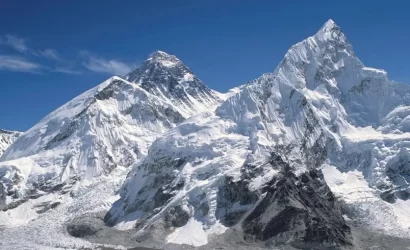
Nestled amidst the Dhaulagiri mountain and the high Tibetan plateau, the Dolpo region is a veritable Shangri-La of your fantasies. Let’s go Upper Dolpo Trekking with Nepal Eco Adventure to a supposedly sacred place for pious Buddhists founded by Guru Rinpoche.

Trekking in the Upper Dolpo is an adventure of a lifetime. trekking to a secluded and distant part of Nepal’s mid-western area to observe the terrain in its unspoiled, untamed state and to come to terms with its remoteness. For hikers seeking an alternative to the crowded, popular trekking routes, the majority of the territory remains unknown and uncharted.

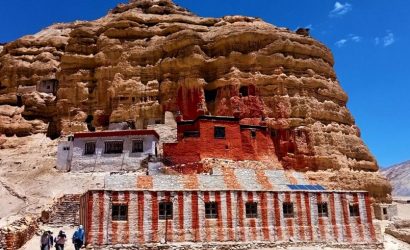
Until 1989, trekkers were prohibited from entering the entire district. As a result, this area is among the oldest and best preserved in the world. The area has only previously been studied by a small number of geographers and anthropologists. With a special authorization from Nepal Eco Adventure, organised trekking groups were able to trek in the Upper Dolpo.

Overview

Travel is the movement of people between relatively distant geographical locations, and can involve travel by foot, bicycle, automobile, train, boat, bus, airplane, or other means, with or without luggage, and can be one way or round trip. Travel can also include relatively short stays between successive movements.

The origin of the word “travel” is most likely lost to history. The term “travel” may originate from the Old French word travail, which means ‘work’. According to the Merriam Webster dictionary, the first known use of the word travel was in the 14th century.

It also states that the word comes from Middle English travailen, travelen (which means to torment, labor, strive, journey) and earlier from Old French travailler (which means to work strenuously, toil). In English we still occasionally use the words “travail”, which means struggle. According to Simon Winchester in his book The Best Travelers’ Tales (2004), the words “travel” and “travail” both share an even more ancient root: a Roman instrument of torture called the tripalium (in Latin it means “three stakes”, as in to impale).


Itinerary

We will take a 60-minute flight from Kathmandu to Nepalgunj. You can explore this energetic city or spend the evening in your hotel after a long day of sightseeing.

We will fly to Juphal from Nepalgunj; the flight will take approximately 35 minutes. We will meet up with our trekking group once we get in Juphal, and we will then travel down the tight canyon and past the verdant terraced farms beside the Bheri River. We will arrive at a sizable settlement called Dunai after three hours of hiking, where we will spend the night.

We're going to head west from Dunai after crossing the suspension bridge. We shall follow the Suli Gad river and head north at the confluence of the Thuri Bheri with it. With the sound of the river thriving in the background, we shall walk up gradually. We'll stroll through fields of potatoes, pumpkins, millet, and marijuana. We're going to go along the river till we get to Hanke, a little village. It is the entrance to the national park of Shey Phoksundo. To go to Ankhe, we'll have to walk through Rahagaon and Parela. It's intriguing that these names correspond to the eyes, eyebrows, and lashes, respectively.

This is where the walk starts to become a little more difficult. Following a well-constructed bridge crossing of a diminishing river, we will ascend a steep terrain along a narrow path. From there, we will make our way down the river for a while before climbing back up to enjoy the stunning view of the surroundings. We might set our camp by the Suligad River.

Our plan is to begin early in the morning. For the first few hours of the hike, it will be fairly easy. We'll take a sharp decline from Sumdo. We'll ascend a hill at 3,875 metres to get a breathtaking view of Phoksundo Lake and Nepal's largest waterfall, which is 300 metres high. We will descend through lovely birch trees to arrive at Phoksundo Khola and the lovely village of Ringmo, which is adorned with Mani walls and Chortens made of mud plaster. It's a bright, energetic village. We'll travel a short distance from here to the Phoksundo Lake shoreline, where we'll pitch up tent.

We'll walk the daring path that hangs from a wooden walkway held up by pegs hammered into the crevices in the rocks. We will climb sharply to 4,040 metres before descending to the valley floor and entering the Shey Phoksundo Khola bank, where we will set up camp for the night.

A couple streams will be crossed by us barefoot! We're going to travel north and cross the glacier valley. The trail will pass through striking vertical cliffs and uneven rock formations as it continues to get narrower. It goes without saying that we will cross the really old wooden bridge that is located at the confluence of the Phoksundo River and another nameless river. We will reach a sheep pasture area after a strenuous, long ascent, from whence the trail ascends a quiet gorge. We will reach a new valley with a view of the daring Kang La Pass after a further arduous and lengthy climb to the summit. We are going to an overnight camp for the night.

Today's walk is particularly taxing and strenuous. We will need about three hours to get to the 5,151-meter Kang La Pass's summit. The reward for all your hard effort is the breathtaking vista from the top. We need to take great care as we descend the steep valley floor. It won't take more than forty-five minutes. Your arrival in Shey Gompa will be indicated by a stunning crimson Chorten. We will cross an antiquated wood bridge to get at the Shey Gompa compound, where we will camp for the night.

In Tibetan, shey literally means "crystal." Another name for this monastery is Crystal Mountain. We can go to the Shey Gompa and receive the Lama's blessings. To the west of Shey, we can go to the Tsakang Gompa. In the Middle Ages, it served as a hub for lamas to meditate. In the eleventh century, the monastery was constructed.

This is where we can see the harmonious fusion of Tibetan Buddhism with the antiquated Bon Po Pre-Buddhist religion. Later on, we can walk around and investigate the surrounding surroundings.

We'll begin the day with a walk along a nice trail lined with juniper bushes. We're going to climb up into a grey, stony canyon. It starts with a winding path made of pebbles and decomposed earth that leads to a level area that would be perfect for a little picnic. After a tough 20-minute climb, we will arrive at the summit of Saldand La Pass. From this vantage point, we have an amazing perspective of Mustang's desolate and coppery red surroundings. After that, it will likely get longer and more exhausting as we head north. It will be pleasant to see the yaks grazing and the nomadic tents made of yak hair. You have now reached the Namduna Gaon, as indicated by this.

Here, the Namgung Monastery, which is situated against the cliff, is open for visitation. With terraced fields on both sides, the village consists of just six dwellings. The district's primary product, barley, is visible in these enormous fields. We can go to the stunning monastery that was just constructed on the outside.

We are going to walk upwards after we leave the Namjung Valley. The journey starts with a protracted and thrilling ride across the steep highlands. Ripe crops are arranged in terraced fields at the bottom of the valley. We will climb for a while before descending to the lovely settlement of Salding, which is perched on a plateau well above the Nam Khong Nala River. It is the district's largest village. On the Tibetan plateau that crosses the Himalayas, there lies an arid settlement.

Early in the morning, we will depart from Saldang and travel along the riverbank, passing by terraced fields, stunning stupas, and Chortens. While travelling, we can stop at the Chaiba Monastery and see any Mani stones. We'll pass via Namdo, a thriving village with 400 residents and 60 dwellings. We can go to the monasteries at Namdo and the other one above the cliff. We'll set up camp along the riverbank close to the community known as Sibu. We're going to an overnight camp for the night.

The first few hours of the walk will be rather easy as you follow the river that is becoming smaller. We will cross another stream after two hours and then head into a side valley. From there, it's a fairly steep ascent. After that, we will come to a lovely meadow that is mostly covered in rocks. We'll spend the night at the overnight camp.

Walking on the trail today is easier because it has been compacted. But it gets really steep at points. The ascent of Jeng La will just take two hours to complete. This location offers a particularly captivating view of the Dhaulagiri Mastiff. In the few hours that separate us from Tarap Chu, we will find ourselves in a verdant, lush valley following a rugged trail that descends towards the Tarap Valley. Tarap, which stretches 20 km along the Tarap Chu, is a genuinely magnificent valley with wide meadows on the foot of snow-capped mountains. When we go to Tokyu Gaon, we can explore the Chortens and Gompas. We can stay overnight on the grounds of Tokyu Monastery. The Chaiba sect is the owner of the monastery.

Today's trail is wide and reasonably challenging. As we go through the fields, we will be able to observe the men and women working hard to harvest the crops. Additionally visible are the Mani Walls and Chortens, many of which currently require renovation. There are not many Tibetans living in Tarap; most of the residents are Magars. The locals are Buddhists or Bon Po devotees. Here is a Gompa where we can go visit and get blessings from the local Lama. At the location, we'll camp out for the night.

We shall descend in the direction of the Tarap Khola. Along the journey, we'll traverse some narrow gorges. It's possible to spot blue sheep, yaks, and individuals bringing their goats and yaks for grazing. As we get away from the river, the path will become more narrow. We're going to cross a contemporary suspension bridge. In several spots, the track will get extremely tight. We're going to an overnight camp for the night.

We are going to keep going down the Tarap River Canyon. We'll be walking on paths today that range from wide and smooth to extremely steep and small. We will also assemble the flights of artificial staircases, which require caution when ascended. Beneath large trees, our campsite will be a lovely and peaceful meadow. We're going to an overnight camp for the night.

We will walk down the river, sometimes going uphill and sometimes downhill, as we leave Khani Gaon and the mountains in the background via a recently constructed suspension bridge. The trail can get more difficult at times, and we'll have to cross one of the rivers on muddy stepping stones!

We will mostly climb down, leaving behind the crazy adventures of the trips back up there. We'll stroll by the resounding Bheri River till we arrive at Dunai settlement. We have now finished exploring the entire stunning Dolpo circuit. When we get there, we'll relax before going exploring.

We're heading back to Juphal, the tiny town. The track is wide and level at first, but it gets steeper and steeper as we ascend. We're going to an overnight camp for the night.

On the same day, we will board the two aircraft. We will take a 35-minute flight to Nepalgunj then a 60-minute flight from Nepalgunj to Kathmandu. It will then be time to bid adieu. I hope to see you again soon!

Includes

  • One night standard hotel on bed and breakfast (B/B) hotel At Nepalgunj.
  • Full board meal (veg. /non veg.) during camping, prepared by our expert cook with Tea & coffee.
  • Boiled and purify drinking water for the trek.
  • Twin sharing tented accommodation and other equipment during the camping trek. We will provide fully water proof two men tent, dining tent, kitchen tent, Table with chairs, kitchen utensils, toilet tents etc.
  • A government licensed English speaking Guide during the trek. A cook, Kitchen helper, required number of porters, their food, accommodation, salary, insurance, equipment and medicine.
  • Medical supplies (first aid kit will be available).
  • Arrangement of Emergency Helicopter service which will be paid by your Travel insurance company.
  • Down sleeping bag / Jackets, walking sticks, and other necessary equipments during the trek. (If you don`t have you own)
  • Use of sleeping bag, down Jacket and walking Poles (if you don’t have your own, To be return after trip completed). Using these 3 items you pay $10 USD each as maintenance and washing charge.
  • Special Trekking upper Dolpo permit and other required paper documents.
  • Flight fare from Kathmandu-Nepalgunj-Juphal -Nepalgunj-Kathmandu including airport departure taxes.
  • All our government taxes tourist service charges. official expenses.
  • Oxymeter to check your pulse and oxygen saturation and heart rate twice daily (Very useful to check Altitude Mountain Sickness(AMS) symptoms) Which will ensure you trek is in the safest hands possible for all levels of trekker.
  • Satellite phone for emergency.

Excludes

  • Airport pick-up and drop for your international flight
  • Accommodation and meals in Kathmandu.
  • Nepal entry visa fees $50 USD for 30 days visa on arrival.
  • Your Travel insurance
  • International airfare
  • Your personal expenses
  • All the alcoholic and non alcoholic hot and cold drinks
  • Tips for trekking staff and driver (Tipping is expected)
  • Any other expenses which are in mentioned on include section
How fit do I need to be to do this trek?

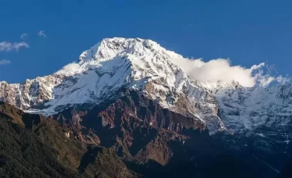
Annapurna Base Camp is a Grade B or a moderately difficult trekking route. So any fit person can do this trek, even if you do not have any previous experience. You should be aware of what to expect and mentally prepare for it. Then, as long as you will to, you can.

How long do we walk every day when doing Annapurna Base Camp trekking?

On average, you walk about 4 to 6 hours per day. One or two days can be as less as 3hrs and one or two days can be as long as 7hrs.

What is the highest altitude reached in this trek?

The highest altitude reached is 4190m. This is the elevation of Annapurna Base Camp. ABC is the highest we will climb in this trek.

What about battery charging and hot shower facilities?

Yes, you can charge batteries en route. Charger should be brought. There are hot shower facilities as well. You may have to pay certain amount for both ($1-$2). Negotiate. Also, hot water facility could be free at lower elevation.

Are there ATMs on the way to Annapurna Base Camp?

No. There are no ATMs on this trek route. You will have to draw enough cash in Pokhara or Kathmandu. There are a number of ATMs in these cities. Everything is paid in Nepali rupees. So money should be exchanged before the start of the trek.

What about internet access?

Yes. Internet can be accessed in most places. Sometimes, there might be some technical problems. Internet in Nepal is not as fast as you are used to and at times you can just lose connection.

Is it necessary to hire Guides/trekking agency for Annapurna Base Camp trekking?

Not really. It depends on you. If you want, ABC trekking can be done independently. You could hire a guide and a porter by yourself instead of going through an agency or not hire a guide at all. Although, not having a guide can be a little problematic during off season.

It really depends on you. Is it your first time in Nepal? How confident are you of being able to find your way around? How pressed on time are you? If you go through an agency, it will be costlier but everything will be planned. You will only have to come, trek and return.

How much do guides and porters cost?

For Annapurna region, pay for guides range from $20 to $30 per day and porters take $15 to $25 per day.

You can send your enquiry via the form below.

Upper Dolpo Trekking

Trip Facts

  • 1-12 people
  • Kathmandu
  • Kathmandu
  • 5125m

Customize Trip